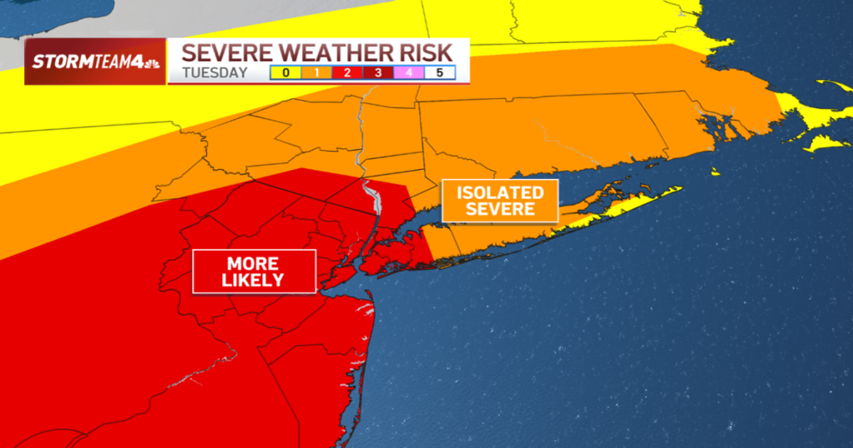
Tornado warnings were issued for parts of New Jersey as thunderstorms brought powerful straight-line winds and carried the potential for isolated flash flooding.
Monmouth and Ocean counties in New Jersey were under a tornado warning for a portion of Tuesday evening. The same line of storms also sparked severe thunderstorm warnings in parts of New York City. Earlier in the day, a different round of storms triggered similar warnings north of the city.
There were some reports of damage, but not nearly as many as the ones that slammed parts of the tri-state last week, which left three people dead. Tuesday’s storms hit the Monmouth County town of Little Silver in particular, bringing down some wires and trees, one of which landed on a home. No injuries were reported.
A severe thunderstorm watch was in effect until 10 p.m. Tuesday for most of the tri-state area, along with a flood watch through midnight for the entire region.


Tuesday’s storms were turbo-charged by copious moisture in the atmosphere, an approaching cold front and extreme heat – all destabilizing weather conditions.
Majority of the area was under a heat advisory through the evening. Air temperatures topped 90 degrees in most locations with heat index readings in the triple digits.

Tuesday’s dew points, the measure of moisture in the atmosphere, have held in the mid 70s all day. That’s tropical humidity – thanks in part to tropical storm Chantal injecting a deep slug of moisture into our region. And the more moisture-rich our air is, the greater the potential is for torrential, flooding rainfall.
The high humidity means that there is a lot of moisture in the atmosphere for storms to draw from and heavy downpours are likely. That’s why the flood watch is in effect.
Any flooding will not be widespread, but rainfall rates of 1 to 2 inches an hour are possible. This will result in excessive runoff, allowing rivers to rise out of their banks, contributing to the flash flood threat.
Rain totals will not be staggering across the board; there will be areas that receive less than a tenth of an inch. But in the spots where those localized downpours set up for an extended period of time, you could be looking at totals approaching, and in some cases exceeding, 2 inches. But, again, these higher rain totals will be isolated.

Timing for the showers and storms was primarily during the evening commute. Isolated storms started to pop through the mid and late afternoon, but the more widespread shower and storm chances arrived around the time many were getting in their cars to drive home.
Bursts of heavy rain were accompanied by reduced visibility.

In addition to the heavy pockets of rain, these storms brought with them the threat for damaging wind gusts up to 60mph. The gusts were strong enough to blow branches off of trees and even down power lines.
Make sure any outdoor furniture is either tied down or taken inside; you don’t want to come home to find your patio chairs have blown into the neighbor’s yard.
The winds led to thousands losing power in New York and especially in New Jersey, where more than 19,000 outages were reported as of 10 p.m.

We get a reprieve from the heavier showers Wednesday, with just a slight chance of storms passing to the south late in the evening. But the remainder of this week continues our unsettled pattern as a series of fronts meander across our area.
Every day won’t be a washout, but you’ll want to keep the umbrella packed in your bag, as we may not see a completely dry day until Sunday. And even then, our dry break will be short-lived.