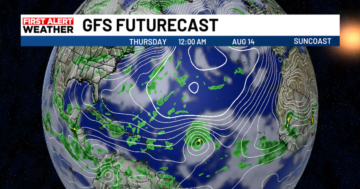
SARASOTA, Fla. (WWSB) – All eyes are locked on the Atlantic tonight.A tropical system known as Invest 97L is showing all the signs of strengthening, and it likely to become the season’s first hurricane in the days ahead.
Some early computer models try to turn it north before it gets close to Florida, but it is simply too early to count on that. We’re tracking every update and will let you know the moment confidence grows in where this storm is headed.
The National Hurricane Center gives it a 90% chance of becoming a tropical depression or storm this week, and it could become a hurricane later. It would be named Erin.
While there are no immediate U.S. impacts, we’ll track it closely all week on ABC7 and MySuncoastcom.
Farther northwest in the north-central Atlantic, Disturbance 2 has only a 20% chance of development over the next week and poses no threat to land.
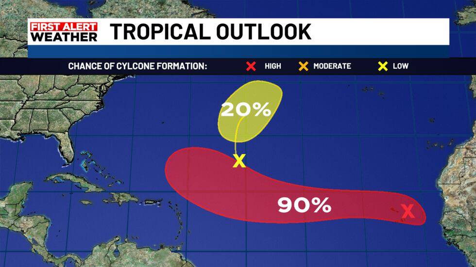
The NHC likely to name Tropical Storm Erin this week and could see season’s first hurricane.(WWSB)
Suncoast weather changing?
At the start of the week, the air over us is loaded with tropical moisture, like walking around in a warm, wet blanket. That is perfect fuel for big afternoon thunderstorms.
By Friday, there is still moisture, but not as much. Think of it as wringing out part of that blanket. It is damp, but not dripping.
Meteorologists measure this using something called precipitable water. It tells us how much water is in the entire column of air above us, from the ground to the top of the atmosphere. If you could squeeze it all out, it is how deep the puddle would be.
Early this week, that number is over 2 inches, meaning the air could give you a puddle more than two inches deep. That is very juicy for storms. By Friday, it is closer to 1.7 to 1.8 inches, which is still damp but not as storm-friendly.
On top of that, the air high above gets a little warmer, which makes it harder for storms to grow tall and strong. Fewer tall clouds mean fewer big thunderstorms, and the ones that do form will not last as long.
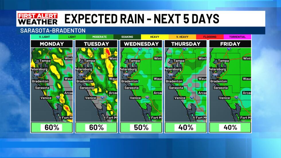
Models show decreasing rain chances by midweek.(WWSB)
Sea breeze still in play
The daily sea breeze will still spark activity, but Friday’s forecast shows a weak westerly component in the afternoon. That tends to keep the storms right along the coast instead of letting them push inland and then back toward the beaches later in the day.
Looking ahead
Even with slightly lower rain chances, keep the umbrella handy. Any storms that do form could still produce heavy rain, frequent lightning, and gusty winds. And if Gulf moisture returns a bit sooner than expected, weekend coverage could end up higher than currently forecast.
Monday Marine Forecast
Winds: Southeast 8–10 knots, becoming southwest in the afternoonSeas: Around 2 feet early, subsiding closer to 1 foot by midweekBay/Intracoastal: A light chopStorms: Best chance late afternoon into evening nearshore as sea breeze pushes back to the coast
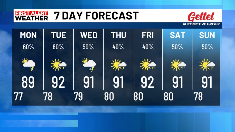
The7 day forecast shows decreasing rain chances this week.(WWSB)
7-Day Outlook
Highs stay hot, generally in the low to mid-90s, with feels-like temperatures running 102 to 106 in the afternoons. The next few days will feature the typical inland-to-coast storm progression, with most coastal areas seeing activity late in the day.
Copyright 2025 WWSB. All rights reserved.