The first named tropical storm of the 2025 Atlantic season, Chantal, made landfall in the Carolinas on the Fourth of July weekend, ahead of a predicted above-average season.
Chantal hit shore on Sunday morning near Myrtle Beach, per CNN, with sustained winds between 50 and 60 mph.
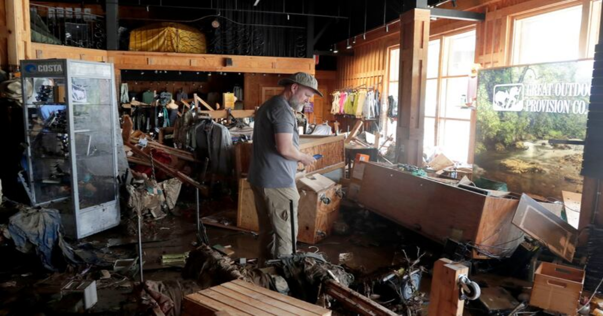
By Sunday evening, Chantal reached North Carolina causing flash floodings in Alamance and Chatham counties with deadly consequences.
The North Carolina State Highway Patrol found Sandra Portnoy Hirschman, 83, dead in Chatham County. Her car was swept about 100 feet off the roadway after she drove into floodwater.
According to CNN, the National Weather Service recorded rainfall amounts of 4 to 7 inches, with localized amounts in excess of 8 inches, and a 20-foot rise in the Eno River, which runs through Orange and Durham counties in North Carolina.
As Chantal, now a tropical depression, winds down on its way northeast, 2 to 3 inches of rain are possible in Virginia, Maryland, Delaware, Pennsylvania and New Jersey, per CNN.

This image provided by the National Oceanic and Atmospheric Administration shows Tropical Storm Chantal as it moves from South Carolina into central North Carolina on Sunday, July 6, 2025. | NOAA
What’s the 2025 hurricane forecast?
Earlier this year, the National Oceanic and Atmospheric Administration released a statement predicting an above-average hurricane season with 13 to 19 total named storms, from which six to 10 are expected to become hurricanes, including three to five becoming major hurricanes.
According to the statement, NOAA has the latest advanced models and warning systems, with a 70% confidence in these ranges.
In that statement, Commerce Secretary Howard Lutnick stated, “With these models and forecasting tools, we have never been more prepared for hurricane season.”

A pie chart provided by NOAA shows an active 2025 Hurricane Season during a news conference on Thursday, May 22, 2025, in Gretna, La. | Stephen Smith
However, the NOAA recently discontinued the “ingest, processing and distribution” of data collected by three weather satellites that are run jointly with the Defense Department, which researchers and forecasters at the National Hurricane Center use, per The Associated Press.
The discontinued satellites collected microwave data, which is critical information to understand the three-dimensional characteristics of a storm that conventional satellites don’t provide, according to AP.
NOAA spokesperson Kim Doster, in a statement, called the discontinued satellites a “routine process of data rotation and replacement” while confirming that remaining data sources “are fully capable of providing a complete set of cutting-edge data and models that ensure the gold-standard weather forecasting the American people deserve.”
But researchers and forecasters that use the microwave data to see the center of the storm and detect the path of dangerous weather are worried.
“We will no longer be able to say, OK, this storm is definitely undergoing rapid intensification, we need to update our forecasts to reflect that,” Marc Alessi, Union of Concerned Scientists science fellow, told AP.
The change is yet another blow for NOAA and its National Weather Service, which have been a target of the Department of Government Efficiency’s cuts.
What to do before a storm?
Here’s a checklist by the National Weather Service.
- Are you in a hurricane evacuation area? Contact your local government/emergency management office to find out if you live in a vulnerable zone. Or check this website.
- Do you have an emergency kit? A basic emergency kit should have enough water and food supplies for several days, a battery-powered radio, flashlight, first aid kit, whistle, local maps, manual can opener, etc.
- Do you have an emergency plan? Sit down with your family and decide beforehand how you will respond in the event of a disaster — how you will get in contact with each other, where you will go, etc. Keep a copy of your plan in the emergency kit and make sure everyone knows it.
- Do you know your insurance policies? Check your insurance policies and make sure you have adequate coverage for your home and personal property.

A man tries to dry his car out in a parking lot at University Place shopping center after it was flooded out during tropical storm Chantal, Monday, July 7, 2025, in Chapel Hill, N.C. | Chris Seward
Where to get updates?
The NOAA’s National Hurricane Center issues tropical advisory products at least every six hours at 5 a.m., 11 a.m., 5 p.m., and 11 p.m. EDT. When a watch or warning is in effect, the NHC will issue advisories every three hours.
Alerts will be on TV and radio, in addition to the hurricane center’s website. The Centers for Disease Control and Prevention’s website explains the difference between the two kind of alerts:
- Hurricane watch: Conditions for a hurricane are possible in a stated area. A watch is issued 48 hours before they expect sustained winds of 39 to 73 mph to start.
- Hurricane warning: Hurricane-force winds are expected in a stated area. A warning is issued 36 hours before sustained winds of 74 mph or higher are expected.

Chairs, umbrellas and a larger garbage container were among the debris washed up at the Shake Shack in the Eastgate Shopping Center after it was flooded during tropical storm Chantal, Monday, July 7, 2025, in Chapel Hill, N.C. | Chris Seward